
Compass surveying is an essential aspect of modern engineering and geography, providing crucial data for mapping and construction. However, like any precise measurement method, compass surveying is susceptible to errors. Understanding these errors and implementing solutions to mitigate them is paramount for accurate and reliable survey results. This article delves into the causes of errors in compass surveying and offers practical solutions to overcome them. Error Analysis in Compass
Understanding Compass Surveying Errors
Instrumental Errors
Instrumental errors arise from imperfections in the survey instrument itself. Common causes include:
Magnetic Needle Defects: If the magnetic needle is not perfectly balanced or has been magnetized unevenly, it can lead to incorrect readings.
Pivot Friction: Excessive friction at the pivot point of the needle can cause it to stick, leading to inaccurate measurements.
Graduation Errors: Inaccuracies in the graduation of the compass dial can also contribute to errors.
Solution: Regular calibration and maintenance of the surveying instruments are essential. Ensuring the magnetic needle is in optimal condition, minimizing pivot friction, and verifying the accuracy of the graduation can significantly reduce instrumental errors.
Observational Errors
Observational errors are due to the human element in the surveying process. These can include:
Parallax Errors: Misreading the compass due to the angle of view.
Misalignment: Incorrect alignment of the compass with the line of sight.
Personal Bias: Individual tendencies to round off readings can lead to systematic errors.
Solution: Training surveyors to take readings correctly, using techniques to eliminate parallax (such as looking directly down at the compass), and implementing a standard procedure for recording data can help mitigate observational errors.
Natural Errors
Natural errors occur due to environmental factors, such as:
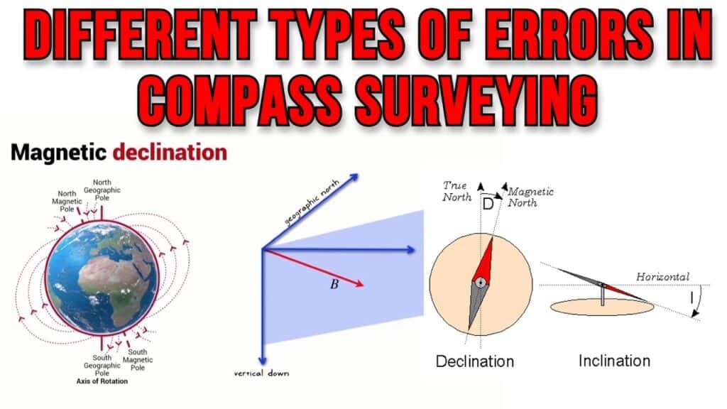
Magnetic Declination: The angle between true north and magnetic north varies by location and changes over time.
Local Attraction: Nearby metallic objects or geological formations can distort the magnetic field.
Weather Conditions: Extreme temperatures and humidity can affect the performance of the compass.
Solution: Regularly updating magnetic declination values from reliable sources, conducting surveys away from large metallic structures, and choosing appropriate times and conditions for surveying can reduce natural errors.
Advanced Solutions for Minimizing Compass Surveying Errors
Use of Gyrocompasses
Gyrocompasses provide a north reference based on the rotation of the Earth rather than magnetic fields. This eliminates errors due to magnetic declination and local attraction.
Benefits:
Highly accurate direction finding.
Unaffected by magnetic disturbances.
Integration of GPS Technology
Combining GPS with compass surveying can significantly enhance accuracy. GPS provides precise positioning data that can be cross-referenced with compass measurements.
Benefits:
Accurate location data.
Complements traditional compass measurements for enhanced reliability.
Automated Data Collection Systems
Automated systems reduce human errors by eliminating the need for manual readings and recordings. Modern surveying instruments often come with digital displays and data logging capabilities.
Benefits:
Minimizes observational errors.
Provides precise and repeatable measurements.
Best Practices for Accurate Compass Surveying
Regular Instrument Calibration
Frequent calibration of instruments ensures they remain accurate over time. Calibration should be done according to manufacturer guidelines and verified against known standards.
Thorough Survey Planning
Planning surveys meticulously can help identify potential sources of error beforehand. This includes understanding the terrain, environmental conditions, and the need for any special equipment.
Use of Redundant Measurements
Taking multiple measurements and averaging them can reduce random errors. Redundant measurements help identify and correct outliers.
Continuous Training and Education
Ongoing training programs for surveyors ensure they stay updated with the latest techniques and technologies. Well-trained surveyors are less likely to make observational errors.
Conclusion
Error analysis in compass surveying is critical for achieving accurate and reliable results. By understanding the sources of errors—whether instrumental, observational, or natural—and implementing solutions such as regular calibration, using advanced technology like gyrocompasses and GPS, and adhering to best practices, we can significantly minimize these errors. Maintaining a high standard of survey practices ensures the data collected is trustworthy, forming the foundation for precise mapping and construction projects.